KSGF - Springfield/Branson National
Located in Springfield, MO, USA
ICAO - KSGF, IATA - SGF, FAA ID - SGF
Airport Type
Civil
Lat/Long
N37-14.7/W093-23.3
Elevation (ft)
1268
Fuel Available
AVGAS JET
Current UTC
8:06:36 AM (-6.00)
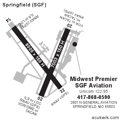
Approaches
ILS LOC GPS
Longest Primary Runway (ft)
8000 x 150, 14/32
Runway Surface
Concrete/Grooved
PCN
Local Standard Time
3:06:36 AM
More Airport Information (Click to expand)
Airport Light Intensity
HIGH
US Customs Pre-Clearance
Yes
DST
2nd Sun in Mar 0200L to 1st Sun in Nov 0200L
Distance from City
5 MILES NW OF CITY
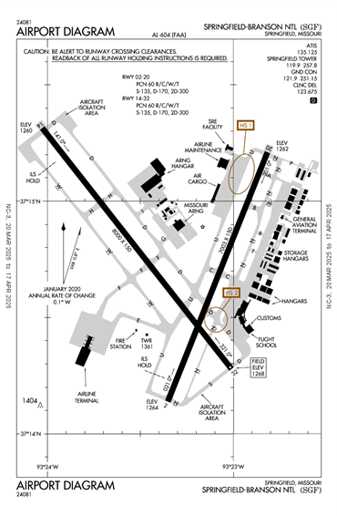
Runway Diagram
FAA Diagram
Google Satellite Map of KSGF
Airport Distance Calculator
The distance from to is
Nautical Miles
Airport Restrictions and Information
CUSTOMS LRA PPR - MIN 8 HRS PN
CUSTOMS LRA PPR - MIN 8 HRS PN
FBOs
Address
2801 N General Aviation Ave, Springfield Branson National,
Springfield, MO 65803
Fuel Info
Brand PHILLIPS 66
JET A
$0.00
$0.00
$0.00
$0.00
JET A-1
$0.00
$0.00
$0.00
$0.00
100LL
$0.00
$0.00
$0.00
$0.00
SAF
$0.00
$0.00
$0.00
$0.00
Price/Gallon
Prices Not Updated Last 90 DAYS
FBOs Click
HereTo Update Fuel Prices
Prices Not Updated Last 90 DAYS
FBOs Click
Here
Update Fuel Prices
Hotels
Holiday Inn Springfield I-44