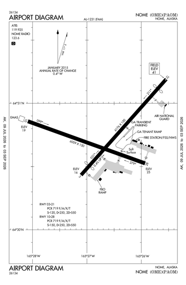
PAOM - Nome
Located in Nome, AK, USA
ICAO - PAOM, IATA - OME, FAA ID - OME
Airport Type
Civil
Lat/Long
N64-30.8/W165-26.7
Elevation (ft)
41
Fuel Available
AVGAS JET
Current UTC
2:57:46 AM (-9.00)
Approaches
ILS/DME GPS
Longest Primary Runway (ft)
6176 x 150, 03/21
Runway Surface
Asphalt/Grooved
PCN
Local Standard Time
6:57:46 PM
More Airport Information (Click to expand)
Airport Light Intensity
MEDIUM
US Customs Pre-Clearance
No
DST
2nd Sun in Mar 0200L to 1st Sun in Nov 0200L
Control Tower Hours
0700-2100L
Distance from City
2 MILES W OF CITY
FAA Diagram
Google Satellite Map of PAOM
Airport Distance Calculator
The distance from to is
Nautical Miles
Airport Restrictions and Information
CUSTOMS LRA PPR - MIN 1 HR PN
CUSTOMS LRA PPR - MIN 1 HR PN
Fuel Info
Brand INDEPENDENT
Fuel Info
Brand INDEPENDENT