MYER - Rock Sound International
Located in Eleuthera Island, BAHAMAS
ICAO - MYER, IATA - RSD
Airport Type
Civil
Lat/Long
N24-53.5/W076-10.7
Elevation (ft)
16
Fuel Available
NO FUEL
Current UTC
12:48:46 AM (-5.00)
Approaches
VFR
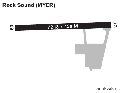
Longest Primary Runway (ft)
7213 x 150, 09/27
Runway Surface
Asphalt
Local Standard Time
8:48:46 PM
More Airport Information (Click to expand)
Airport Light Intensity
MEDIUM
US Customs Pre-Clearance
No
DST
2nd Sun in Mar 0200L to 1st Sun in Nov 0200L
Airport Hours
M-F 1400-2200Z, O/T O/R
Distance from City
3 KM NNW OF TOWN
Runway Diagram
Google Satellite Map of MYER
Airport Distance Calculator
The distance from to is
Nautical Miles
Airport Restrictions and Information
Handlers
Address
Rock Sound International Airport,
Rock Sound, Eleuthera
Tel After Hours
+1 242 557 0227