KTXW - Mid Valley
Located in Weslaco, TX, USA
ICAO - KTXW, FAA ID - TXW
Airport Type
Civil
Lat/Long
N26-10.7/W097-58.4
Elevation (ft)
70
Fuel Available
AVGAS JET
Current UTC
10:51:32 AM (-6.00)
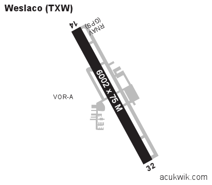
Approaches
GPS VOR/DME
Longest Primary Runway (ft)
6002 x 75, 14/32
Runway Surface
Asphalt
PCN
Local Standard Time
5:51:32 AM
More Airport Information (Click to expand)
Airport Light Intensity
MEDIUM
US Customs Pre-Clearance
No
DST
2nd Sun in Mar 0200L to 1st Sun in Nov 0200L
Airport Hours
Ops H24; Attended M-Sa 0700-1800L, O/T PPR
Distance from City
1 MILE NE OF CITY
Runway Diagram
Google Satellite Map of KTXW
Airport Distance Calculator
The distance from to is
Nautical Miles
Airport Restrictions and Information
CUSTOMS LRA PPR - MIN 24 HRS PN
CUSTOMS LRA PPR - MIN 24 HRS PN