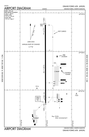
KRDR - Grand Forks Afb
Located in Grand Forks, ND, USA
ICAO - KRDR, FAA ID - RDR
Airport Type
Military
Lat/Long
N47-57.7/W097-24.0
Elevation (ft)
911
Fuel Available
NO FUEL
Current UTC
12:37:16 AM (-6.00)
Approaches
VFR
Longest Primary Runway (ft)
12351 x 150, 18/36
Runway Surface
Asphalt/Grooved
PCN
Local Standard Time
7:37:16 PM
More Airport Information (Click to expand)
Airport Light Intensity
HIGH
US Customs Pre-Clearance
No
DST
2nd Sun in Mar 0200L to 1st Sun in Nov 0200L
Distance from City
13 MILES W OF CITY
FAA Diagram
Google Satellite Map of KRDR
Airport Distance Calculator
The distance from to is
Nautical Miles