KMIV - Millville Municipal

Located in Millville, NJ, USA

ICAO - KMIV, IATA - MIV, FAA ID - MIV

Airport Type 
Civil 
Lat/Long 
N39-22.1/W075-04.3 
Elevation (ft) 
85 
Fuel Available 
AVGAS JET 
Current UTC 
10:01:35 AM (-5.00) 
Approaches 
ILS GPS VOR 
Longest Primary Runway (ft) 
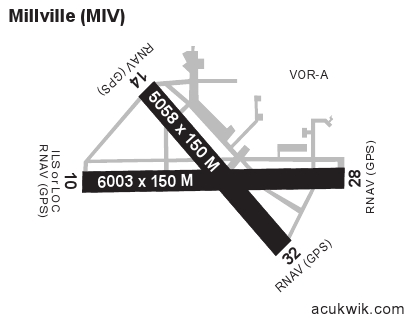
6003 x 150, 10/28 
Runway Surface 
Asphalt/Grooved 
PCN 
055FDWT 
Local Standard Time 
5:01:35 AM 
More Airport Information (Click to expand)
Airport Light Intensity
MEDIUM
Airport of Entry
No
Airport of Entry Remarks
Nil
Fire Category Remarks
Customs
No
US Customs Pre-Clearance
No
Slots Required
No
Handling Mandatory
No
Airport Email
Airport Website
Airport Manager Phone
Airport Ownership
Publicly Owned
Facility Use
Open to the Public
DST
2nd Sun in Mar 0200L to 1st Sun in Nov 0200L
Sunrise
07:09 AM
Sunset
05:16 PM
Open 24 Hours
No
Airport Hours
H24
Control Tower Hours
H24
Variation
11W
Distance from City
3 MILES SW OF CITY
Unicom Frequency
123.0
CTAF Frequency
123.0
Runway Diagram
Google Satellite Map of KMIV
Airport Distance Calculator
From:
To:

The distance from to is

Nautical Miles
Airport Restrictions and Information
Airport Information
Frequency
Phone / Fax
Email / Website
ASOS
119.6
Phone
+1 856 327 3455
ASOS
Phone
+1 856 327 3455

FBOs

FBO Name
Fuel Info
Address
2 Thunderbolt Dr,
Millville, NJ 08332
Phone
+1 856 825 3160
Toll Free Phone
+1 800 752 9207
Fax
+1 856 825 4144
Email
Website
Frequency
123.0

Fuel Info

Brand AVFUEL
Car Rental
ENTERPRISE (VINELAND)
Phone
+1 856 794 1414
Website
HERTZ
Phone
+1 856 825 7173
Website