KINW - Winslow-Lindbergh Regional
Located in Winslow, AZ, USA
ICAO - KINW, IATA - INW, FAA ID - INW
Airport Type
Civil
Lat/Long
N35-01.3/W110-43.4
Elevation (ft)
4941
Fuel Available
AVGAS JET
Current UTC
7:40:31 PM (-7.00)
Approaches
GPS VOR
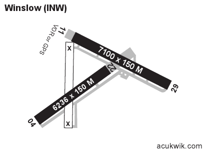
Longest Primary Runway (ft)
7499 x 150, 04/22
Runway Surface
Asphalt
Local Standard Time
12:40:31 PM
More Airport Information (Click to expand)
Airport Light Intensity
MEDIUM
US Customs Pre-Clearance
No
DST
None (No Daylight Savings Time observed)
Distance from City
1 MILE W OF CITY
Runway Diagram
Google Satellite Map of KINW
Airport Distance Calculator
The distance from to is
Nautical Miles
Airport Restrictions and Information
Fuel Info
Brand AVFUEL
Price/Gallon
Last Updated: 21 Jul 2026
Last Updated: 21 Jul 2026