KINL - Falls International/Einarson Field
Located in International Falls, MN, USA
ICAO - KINL, IATA - INL, FAA ID - INL
Airport Type
Civil
Lat/Long
N48-33.9/W093-24.1
Elevation (ft)
1184
Fuel Available
AVGAS JET
Current UTC
7:40:16 PM (-6.00)
Approaches
ILS GPS VOR
Longest Primary Runway (ft)
7400 x 150, 13/31
Runway Surface
Asphalt/Grooved
Local Standard Time
2:40:16 PM
More Airport Information (Click to expand)
Airport Light Intensity
HIGH
US Customs Pre-Clearance
Yes
DST
2nd Sun in Mar 0200L to 1st Sun in Nov 0200L
Control Tower Hours
SR-SS
Distance from City
0 MILES S OF CITY
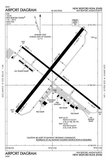
Runway Diagram

FAA Diagram
Google Satellite Map of KINL
Airport Distance Calculator
The distance from to is
Nautical Miles
Airport Restrictions and Information
Hotels
AmericInn International Falls