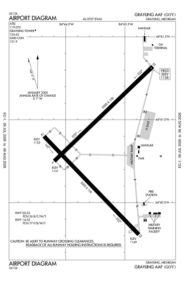
KGOV - Grayling AAF

Located in Grayling, MI, USA

ICAO - KGOV, FAA ID - GOV

Airport Type 
Joint Civil / Military 
Lat/Long 
N44-40.8/W084-43.7 
Elevation (ft) 
1158 
Fuel Available 
AVGAS JET 
Current UTC 
11:27:00 AM (-5.00) 
Approaches 
GPS VOR NDB 
Longest Primary Runway (ft) 
5005 x 150, 14/32 
Runway Surface 
Asphalt 
PCN 
Local Standard Time 
7:27:00 AM 
More Airport Information (Click to expand)
Airport Light Intensity
MEDIUM
Airport of Entry
No
Customs
No
US Customs Pre-Clearance
No
Slots Required
No
Handling Mandatory
No
Airport Manager Phone
Airport Ownership
Facility Use
DST
2nd Sun in Mar 0200L to 1st Sun in Nov 0200L
Sunrise
06:37 AM
Sunset
08:37 PM
Open 24 Hours
Yes
Airport Hours
H24; Admin M-F 0730-1600L
Control Tower Hours
0900-1700L M-F
Variation
06W
Distance from City
1 MILE NW OF CITY
Tower Frequency
ATIS Frequency
CTAF Frequency
Airport General Remarks
FAA Diagram FAA Diagram
Google Satellite Map of KGOV
Airport Distance Calculator
From:
To:

The distance from to is

Nautical Miles
Airport Restrictions and Information
Airport Information
Frequency
Phone / Fax
Email / Website
JOINT USE AIRPORT
AWOS-3
119.075
Phone
+1 989 348 3127
TOWER
126.2
Phone
+1 989 348 5939
JOINT USE AIRPORT
AWOS-3
Phone
+1 989 348 3127
TOWER
Phone
+1 989 348 5939

FBOs

FBO Name
Fuel Info
Address
Phone
Tel After Hours
Email
Website
Frequency
126.2

Fuel Info

Brand AVFUEL
Hotels
Name and Contact Info
Address
Distance
Price range
Fay's Motel
Phone
Website
Address
Distance
5 Min
Price range
North Country Lodge
Phone
Website
Address
Distance
5 Min
Price range
Ramada Grayling
Phone
Fax
Website
Address
Distance
10 Min
Price range
$68-72
Car Rental