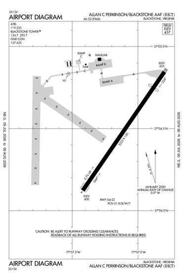
Menu
Products
Data Licenses
Advanced Search
News
About Us
Advertise
Follow Us:
Advanced
Map
Search
Access
Login
My Page
Log Out
KBKT - Allen C Perkinson Blackstone Army Air Field
Located in Blackstone, VA, USA
ICAO - KBKT, IATA - BKT, FAA ID - BKT
Lat/Long
N37-04.5/W077-57.4
Elevation (ft)
437
Fuel Available
AVGAS JET
Current UTC
2:55:12 AM (-5.00)
Longest Hard Surface Runway (ft)
5333 x 150, 04/22
Runway Surface
Concrete
PCN
REGISTER
Local Standard Time
9:55:12 PM
Approaches
GPS NDB
Airport Type
Civil
Airport Light Intensity
MEDIUM
Airport of Entry
No
Customs
No
US Customs Pre-Clearance
No
Slots Required
No
Handling Mandatory
No
DST
2nd Sun in Mar 0200L to 1st Sun in Nov 0200L
Sunrise
7:19 AM
Sunset
5:31 PM
Open 24 Hours
Yes
Airport Hours
H24
Control Tower Hours
M-F 8A-4:30P
Variation
09W
Distance from City
2 MILES E OF CITY
Tower Frequency
REGISTER
CTAF Frequency
REGISTER
Airport Distance Calculator
From:
To:
Calculate
The distance from
to
is
Nautical Miles
Nautical Miles
Miles
Kilometers
NOTAMs
FAA 5010 Data
Instrument Procedures for KBKT
Clearance Overview for KBKT
Passport, Visa, & Health Requirements for KBKT
7 Day Forecast
FBOs
FBO Name
Fuel Brand & Price
PARTNER AVIATION
Address
REGISTER
Phone
REGISTER
Fax
REGISTER
Email
REGISTER
Website
REGISTER
Frequency
122.95
Fuel Price
Brand
SHELL
Airport Restrictions and Information
Airport Information
Frequency
Phone / Fax
Email / Website
AWOS-3
119.225
Phone
+1 434 292 1400
TOWER
Phone
+1 434 292 2047
AWOS-3
Phone
+1 434 292 1400
TOWER
Phone
+1 434 292 2047
Diagrams and Maps
Google Satellite Map of KBKT
Weather
METAR
KBKT 260235Z AUTO 12005KT 7SM OVC003 03/03 A2994 RMK AO1 P0002 T00250025
TAF
*** NO MESSAGES FOUND ***
FC
*** NO MESSAGES FOUND ***
Last Update:
26 Jan 2021 02:35
Temperature (°F)
37
Dewpoint
37
Relative Humidity
100
Wind Direction
120
Gust
Pressure
29.47
Sky
Overcast
Ceiling
300
Visibility
7
Heat Index
37
Wind Chill
32
Wind Speed
6
Extended 7 Day Forecast
°F
°C
Today
41
36
5
2
Day
Night
Periods of rain. Low 36F. Winds light and variable. Chance of rain 100%. Rainfall around a quarter of an inch. Locally heavier rainfall possible.
Rain. Low 2C. Winds light and variable. Chance of rain 100%. Rainfall around 6mm. Locally heavier rainfall possible.
Sunrise: 07:19 AM
Sunset: 05:29 PM
Moonrise: 02:32 PM
Moonset: 04:49 AM
Tomorrow
55
38
13
4
Day
Showers in the morning, then cloudy in the afternoon. Areas of patchy fog. High around 55F. Winds light and variable. Chance of rain 50%.
Showers in the morning, then cloudy in the afternoon. Areas of patchy fog. High 13C. Winds light and variable. Chance of rain 50%.
Night
Partly cloudy. Low 38F. Winds light and variable.
Clear to partly cloudy. Low 4C. Winds light and variable.
Sunrise: 07:18 AM
Sunset: 05:30 PM
Moonrise: 03:24 PM
Moonset: 05:45 AM
Wednesday
53
30
12
-1
Mix of sun and clouds. Highs in the low 50s and lows in the low 30s.
Partly cloudy. Highs 11 to 13C and lows -2 to 0C.
Sunrise:
07:17 AM
Sunset:
05:31 PM
Moonrise:
04:23 PM
Moonset:
06:39 AM
Thursday
42
21
5
-6
Times of sun and clouds. Highs in the low 40s and lows in the low 20s.
Mix of sun and clouds. Highs 4 to 6C and lows -7 to -5C.
Sunrise:
07:17 AM
Sunset:
05:32 PM
Moonrise:
05:27 PM
Moonset:
07:26 AM
Friday
42
20
5
-7
Abundant sunshine. Highs in the low 40s and lows in the low 20s.
Abundant sunshine. Highs 4 to 6C and lows -8 to -6C.
Sunrise:
07:16 AM
Sunset:
05:33 PM
Moonrise:
06:35 PM
Moonset:
08:08 AM
Saturday
43
27
6
-3
Mostly sunny. Highs in the low 40s and lows in the upper 20s.
A few clouds. Highs 5 to 7C and lows -4 to -2C.
Sunrise:
07:15 AM
Sunset:
05:34 PM
Moonrise:
07:44 PM
Moonset:
08:45 AM
Sunday
46
34
8
1
Mix of rain and snow. Highs in the mid 40s and lows in the mid 30s.
Mix of rain and snow. Highs 7 to 9C and lows 0 to 2C.
Sunrise:
07:14 AM
Sunset:
05:35 PM
Moonrise:
08:53 PM
Moonset:
09:18 AM