KBHB - Hancock County/Bar Harbor
Located in Bar Harbor, ME, USA
ICAO - KBHB, IATA - BHB, FAA ID - BHB
Airport Type
Civil
Lat/Long
N44-27.0/W068-21.7
Elevation (ft)
83
Fuel Available
AVGAS JET
Current UTC
7:34:39 PM (-5.00)
Approaches
ILS LOC GPS
Longest Primary Runway (ft)
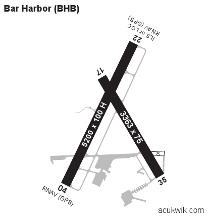
5200 x 100, 04/22
Runway Surface
Asphalt
PCN
Local Standard Time
3:34:39 PM
More Airport Information (Click to expand)
Airport Light Intensity
HIGH
Fire Category
ARFF Index A
US Customs Pre-Clearance
No
DST
2nd Sun in Mar 0200L to 1st Sun in Nov 0200L
Airport Hours
County: M-F 0730-1600L
Distance from City
8 MILES NW OF CITY
Runway Diagram
Google Satellite Map of KBHB
Airport Distance Calculator
The distance from to is
Nautical Miles
Airport Restrictions and Information
Fuel Info
Brand TITAN
Prices Not Updated Last 90 DAYS
Prices Not Updated Last 90 DAYS