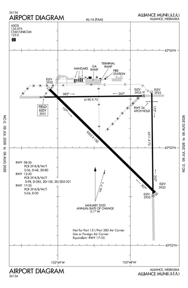
KAIA - Alliance Municipal
Located in Alliance, NE, USA
ICAO - KAIA, IATA - AIA, FAA ID - AIA
Airport Type
Civil
Lat/Long
N42-03.2/W102-48.2
Elevation (ft)
3931
Fuel Available
AVGAS JET
Current UTC
3:22:51 AM (-7.00)
Approaches
ILS LOC GPS
Longest Primary Runway (ft)
9203 x 150, 12/30
Runway Surface
Asphalt/AFSC
PCN
Local Standard Time
9:22:51 PM
More Airport Information (Click to expand)
Airport Light Intensity
MEDIUM
US Customs Pre-Clearance
No
DST
2nd Sun in Mar 0200L to 1st Sun in Nov 0200L
Distance from City
3 MILES SE OF CITY
FAA Diagram
Google Satellite Map of KAIA
Airport Distance Calculator
The distance from to is
Nautical Miles
Airport Restrictions and Information
Hotels
Holiday Inn Express Alliance