ETAR - Ramstein AB
Located in Ramstein, GERMANY
ICAO - ETAR, IATA - RMS
Airport Type
Military
Lat/Long
N49-26.2/E007-36.3
Elevation (ft)
781
Fuel Available
JET
Current UTC
1:06:33 AM (+1.00)
Approaches
ILS GPS
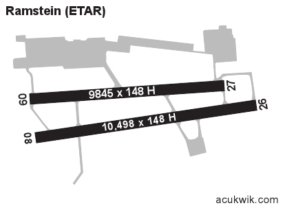
Longest Primary Runway (ft)
10498 x 148, 08/26
Runway Surface
Asphalt/concrete
PCN
Local Standard Time
3:06:33 AM
More Airport Information (Click to expand)
Airport Light Intensity
HIGH
US Customs Pre-Clearance
No
DST
Last Sun in Mar 0100Z to last Sun in Oct 0100Z
Distance from City
4 KM FROM CITY
Runway Diagram
Google Satellite Map of ETAR
Airport Distance Calculator
The distance from to is
Nautical Miles
Airport Restrictions and Information