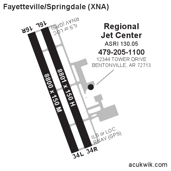
AC-U-KWIK will be exhibiting @ EBACE May 14-16 2012 visit booth #1353 *NEW* FBO Online Update
Acukwik Airport Information

Worldwide Airport and FBO / Handler Data

Business Aviation's Most Respected Flight Planning Resource
follow us:
Facebook  Linked In twitter

KXNA - Northwest Arkansas Rgnl Airport Information

Located in Fayetteville/Springdale, AR United States : ICAO - KXNA, IATA - XNA, FAA ID - XNA
Current UTC: 11:59:15 PM
Local Standard Time: 6:59:15 PM
Fuel Available: AVGAS JET
Elevation (ft): 1288
Max. hard surfaced runway (ft): 8800 x 150
PCN:
AFTN:
Control Tower Phone: NOT PUBLISHED
Control Tower Hours: 0530 - 2300
Airport Email:  
Sunrise: 6:07 AM
Sunset: 8:19 PM
Lat/Long: N36-16.9/W094-18.5
Airport Light Intensity: HIGH
Variation: 04E
Approaches: ILS/DME GPS
Open 24 Hours: Yes
Airport of Entry: No
SITA:
Slots Required: No
Airport Hours:
Airport Website:
Handling Mandatory: No
FBOs  
FBO Names Fuel Brand Frequency Fuel Price  
REGIONAL JET CENTER, INC.
Phone:479-205-1100
Fax:479-205-1101
www.regionaljetcenter.com
View FBO Details
View Comments 

Phillips 66  
130.05
 
   
To update or add your FBO information online, click here.
OR to view and print our standard FBO information form, click here.
Airport Restrictions and Information  
Airport Information Frequency Phone Fax
15 MILES NW OF CITY
ASOS 119.425 479-203-0109

NOTAMs (Click a NOTAM to view full report)
NOTAM # 2/9985
Start Date UTC: 5/9/2012 3:43:00 PM
End Date UTC:
Message: !FDC 2/9985 XNA FI/P IAP NORTHWEST ARKANSAS RGNL, FAYETTEVILLE/SPRINGDALE/, AR. RNAV (GPS) RWY 35, ORIG... LPV DA: VISIBILITY ALL CATS 1/2 MILE. LN. . .
NOTAM # 2/9986
Start Date UTC: 5/9/2012 3:43:00 PM
End Date UTC:
Message: !FDC 2/9986 XNA FI/P IAP NORTHWEST ARKANSAS RGNL, FAYETTEVILLE/SPRINGDALE/, AR. ILS OR LOC/DME RWY 17, ORIG... S-ILS 17: VISIBILITY ALL CATS 1/2 MILE. . . .
NOTAM # 2/9987
Start Date UTC: 5/9/2012 3:43:00 PM
End Date UTC:
Message: !FDC 2/9987 XNA FI/P IAP NORTHWEST ARKANSAS RGNL, FAYETTEVILLE/SPRINGDALE/, AR. ILS OR LOC/DME RWY 35, ORIG... S-ILS 35: VISIBILITY ALL CATS 1/2 MILE. . . .
NOTAM # A0109/12
Start Date UTC: 5/9/2012 3:43:00 PM
End Date UTC:
Message: A0109/12 NOTAMN Q) KZME/QPICH////// A) KXNA B) WIE C) UFN E) QPICH RNAV (GPS) RWY 35, ORIG... LPV DA: VISIBILITY ALL CATS 1/2 MILE. LNAV/VNAV DA: VISI. . .
NOTAM # A0110/12
Start Date UTC: 5/9/2012 3:43:00 PM
End Date UTC:
Message: A0110/12 NOTAMN Q) KZME/QPICH////// A) KXNA B) WIE C) UFN E) QPICH ILS OR LOC/DME RWY 17, ORIG... S-ILS 17: VISIBILITY ALL CATS 1/2 MILE. S-LOC 17: CA. . .
NOTAM # A0111/12
Start Date UTC: 5/9/2012 3:43:00 PM
End Date UTC:
Message: A0111/12 NOTAMN Q) KZME/QPICH////// A) KXNA B) WIE C) UFN E) QPICH ILS OR LOC/DME RWY 35, ORIG... S-ILS 35: VISIBILITY ALL CATS 1/2 MILE. S-LOC 35: VI. . .
NOTAM # 2/9984
Start Date UTC: 5/9/2012 3:42:00 PM
End Date UTC:
Message: !FDC 2/9984 XNA FI/P IAP NORTHWEST ARKANSAS RGNL, FAYETTEVILLE/SPRINGDALE/, AR. RNAV (GPS) RWY 17, ORIG... LPV DA: VISIBILITY ALL CATS 1/2 MILE. LN. . .
NOTAM # A0108/12
Start Date UTC: 5/9/2012 3:42:00 PM
End Date UTC:
Message: A0108/12 NOTAMN Q) KZME/QPICH////// A) KXNA B) WIE C) UFN E) QPICH FI/P RNAV (GPS) RWY 17, ORIG... LPV DA: VISIBILITY ALL CATS 1/2 MILE. LNAV/VNAV DA:. . .
NOTAM # A0104/12
Start Date UTC: 5/2/2012 4:06:00 PM
End Date UTC:
Message: A0104/12 NOTAMN Q) KZME/QMRHW////// A) KXNA B) WIE C) UFN E) QMRHW RWY 16/34 WORK IN PROGRESS EXCAVATING EAST 250 FT
NOTAM # 05/003
Start Date UTC: 5/2/2012 4:06:00 PM
End Date UTC:
Message: !XNA 05/003 XNA RWY 16/34 WORK IN PROGRESS EXCAVATING E 250FT
NOTAM # A0099/12
Start Date UTC: 5/1/2012 10:00:00 AM
End Date UTC:
Message: A0099/12 NOTAMN Q) KZME/QMXLC////// A) KXNA B) 1205011000 C) UFN E) QMXLC TWY C CLSD
NOTAM # 04/011
Start Date UTC: 5/1/2012 10:00:00 AM
End Date UTC:
Message: !XNA 04/011 XNA TWY C CLSD WEF 1205011000
NOTAM # 01/005
Start Date UTC: 1/12/2012 4:42:00 PM
End Date UTC:
Message: !XNA 01/005 XNA RWY 16/34 RWY LGTS PRESET ON HIGH INTST DURG DALGT HRS
NOTAM # A0006/12
Start Date UTC: 1/12/2012 3:58:00 PM
End Date UTC:
Message: A0006/12 NOTAMN Q) KZME/QMRXX////// A) KXNA B) 1201121558 C) UFN E) RWY 16/34 RWY LGTS PRESET ON HIGH INTENSITY DURG DALGT HRS
NOTAM # A0347/11
Start Date UTC: 12/20/2011 10:10:00 PM
End Date UTC:
Message: A0347/11 NOTAMN Q) KZME/QMXLC////// A) KXNA B) WIE C) UFN E) QMXLC TWY A AND TWY K CLOSED WEST OF RWY 16/34
NOTAM # 12/006
Start Date UTC: 12/20/2011 10:10:00 PM
End Date UTC:
Message: !XNA 12/006 XNA TWY A,K CLSD W RWY 16/34
NOTAM # 11/021
Start Date UTC: 11/14/2011 4:48:00 PM
End Date UTC:
Message: !XNA 11/021 XNA SVC ATIS OTS
Diagrams and Maps
AC-U-KWIK Flight Tracker provided by GCR & Associates, Inc.
Full Screen & Flight Details

FREE FLIGHT TRACKING:
AC-U-KWIK now offers FREE Flight Tracking for any airport in the United States or Canada. To see aircraft information, hover over an aircraft on the map or click "Full Screen & Flight Details."

SUBSCRIPTION FLIGHT TRACKING & DETAILED GA ACTIVITY REPORTS:
For companies needing ongoing, detailed analysis of aircraft leaving or arriving at one or multiple airports OR for companies interested in gaining more market share at an airport by having access to detailed general aviation activity reports (including aircraft ownership information), then click here for more details.

Google Satellite Map of KXNA

Runway Diagram

Click here to view larger diagram
KXNA FAA Diagram in PDF
Weather
METAR: KXNA 162353Z 30005KT 10SM CLR 27/13 A3000 RMK AO2 SLP148 T02720133 10294 20267 56006
TAF: LATEST TAF REPORT FOR KXNA TAF KXNA 162320Z 1700/1724 00000KT P6SM SKC FM171600 19006KT P6SM SKC LATEST FC REPORT FOR KXNA *** NO MESSAGES FOUND ***
Temperature (F): 83 Weather:
Dewpoint: 53 Sky: Clear
Relative Humidity: 36 Ceiling: Unl
Wind Speed: 7 Visibility: 10
Wind Direction: 340°, NNW Heat Index: 83
Gust: Wind Chill: 83
Pressure: 30.01 Last Update: 2012-5-16T21:53:00 GMT
7-Day Forcast for KXNA
Wednesday
/images/weatherIcons/65_wtext.jpg Highs Lows
Wednesday night
A stray thunderstorm is possible through the evening. Mainly clear skies. Low 53F. Winds light and variable.
82° F 53° F
27 C 11 C
Sunrise: 6:10 am    Sunset: 8:18 pm    Moonrise: 3:34 am    Moonset: 4:40 pm
Thursday
/images/weatherIcons/85_wtext.jpg Highs Lows
Thursday
Mainly sunny. High 83F. Winds light and variable.
Thursday night
Clear skies. Low 57F. Winds light and variable.
83° F 57° F
28 C 13 C
Sunrise: 6:09 am    Sunset: 8:19 pm    Moonrise: 4:03 am    Moonset: 5:36 pm
Friday
/images/weatherIcons/85_wtext.jpg Highs Lows
Friday
Mainly sunny. Warm. High around 85F. Winds S at 10 to 15 mph.
Friday
Abundant sunshine. Highs in the mid 80s and lows in the low 60s.
85° F 62° F
29 C 16 C
Sunrise: 6:08 am    Sunset: 8:20 pm    Moonrise: 4:35 am    Moonset: 6:31 pm
Saturday
/images/weatherIcons/65_wtext.jpg Highs Lows
Saturday
Plenty of sun. Highs in the mid 80s and lows in the low 60s.
84° F 63° F
28 C 17 C
Sunrise: 6:07 am    Sunset: 8:20 pm    Moonrise: 5:10 am    Moonset: 7:26 pm
Sunday
/images/weatherIcons/84_wtext.jpg Highs Lows
Sunday
Partly cloudy with a stray thunderstorm. Highs in the low 80s and lows in the low 60s.
83° F 61° F
28 C 16 C
Sunrise: 6:07 am    Sunset: 8:21 pm    Moonrise: 5:48 am    Moonset: 8:20 pm
Monday
/images/weatherIcons/84_wtext.jpg Highs Lows
Monday
A few thunderstorms possible. Highs in the upper 70s and lows in the upper 50s.
79° F 59° F
26 C 15 C
Sunrise: 6:06 am    Sunset: 8:22 pm    Moonrise: 6:30 am    Moonset: 9:12 pm
Tuesday
/images/weatherIcons/65_wtext.jpg Highs Lows
Tuesday
Mostly sunny. Highs in the low 80s and lows in the low 60s.
81° F 62° F
27 C 16 C
Sunrise: 6:06 am    Sunset: 8:23 pm    Moonrise: 7:18 am    Moonset: 10:01 pm

Hotels
Name Price Range Distance
Wingate by Wyndham Bentonville AR   more info... $110.08 - $129.73 1.27 mi
Clarion Hotel And Conf Center   more info... $62.99 - $139.95 5.84 mi
Doubletree Guest Suites Bentonville/Rogers   more info... $94.05 - $179.00 5.88 mi
BEST WESTERN CASTLEROCK INN   more info... $70.00 - $89.00 5.95 mi
Embassy Ste Nw Ar Hotel-spa   more info... $102.02 - $159.00 6.00 mi
La Quinta Inn & Suites Bentonville   more info... $69.59 - $89.76 6.20 mi
Holiday Inn Htl Stes Rogers   more info... $78.20 - $87.97 6.49 mi
Comfort Suites   more info... $79.99 - $144.99 6.59 mi
Hilton Garden Inn Bentonville   more info... $109.65 - $149.00 6.63 mi
Holiday Inn Exsts Benntonville   more info... $56.00 - $132.00 6.63 mi
VOR
Vor: RAZORBACK
Ident: RZC
Radial: 279.1
Distance from closest H VOR with a DME: 9.3
Coordinates: W094-07.3/N36-14.8
DME: DME
State: AR
Frequency: 116.4
Variation: 04E
Controlling FSS: JONESBORO
Discrete Frequencies: 122.2 122.3
Type VOR: HIGH
Controlling Center: MEMPHIS CTR
ARTCC Sector Frequencies: 132.55H/126.1L
 
Vor: DRAKE
Ident: DAK
Radial: 332.5
Distance from closest VOR with a DME: 15.3
Coordinates: W094-11.9/N36-02.6
DME: DME
State: AR
Frequency: 108.8
Variation: 07E
Controlling FSS: JONESBORO
Discrete Frequencies: 122.2 122.3
Type VOR: TERM
Controlling Center: MEMPHIS CTR
ARTCC Sector Frequencies: 132.55H/126.1L
KXNA Services Summary
VOR
Acukwik.com


Copyright 2012 Penton Business Media Inc. 9800 Metcalf Ave Overland Park, KS 66212 800-600-6199 or 1-913-967-1719
KWIK Weather Search
Airport ICAO:
Search
KWIK NOTAMs Search
Airport ICAO:
Search
AC-U-KWIK Distance Calculator
ICAO Unit
From:
To:

Calculate
Recently Viewed Airports
Recently Viewed FBOs